cluster map

Friday, August 22, 2014

lowry address changes

I apologize if you have received this multiple times.


Address
5391 Wakefield Beach Lane, Sechelt, B. C. V0N 3A8
Cell phone
604 741 8553
Home phone
604 747 9740


mail:


mark.marklowry@gmail.com


Please use this info from sept 1 . See you on the wet coast


DON’T FORGET THE OAGEE Conference , October 17&18 at Ryerson


Have a great year Mark


Mark Lowry

Geography and Spatial Technologies Instructional Leader

Social World Studies and Humanities

Toronto District School Board

1 Civic Center Court, Toronto , M9C 2B3

Tel (416) 394-7269   Cell (416) 576 -4515

http://tdsbweb/_site/ViewItem.asp?siteid=63&menuid=63&pageid=63

http://geographysites.blogspot.ca/

twitter @geogmark


Wednesday, June 11, 2014

summer institutes & culminating

It’s Culminating Time!

(In more ways than you can imagine)


Summer PD opportunities

OTF Summer Institutes

These are a great opportunity to get some fabulous PD in a different setting.

Two specifically for Geography where you will be immersed in the basics of the new curriculum , including Inquiry , and concepts of geographical thinking plus you will get hands on training in spatial Technologies and field work (using GPS)

Two sites for Geography ( and they are no cost)

Toronto, July 23-25

Sudbury, July 30-Aug 1

Using Inquiry, Concepts of Geographical Thinking and

Spatial Technologies (7-12)

To register, visit otffeo.on.ca and click on 2014 Summer Institutes

As we are doing Culminating’s

I know that everyone is up to their proverbial eyeball in culminating (Evaluative) activities and I have been getting many calls and emails with questions as to their scope and sequence. The following is a Primer and conversation starter on what culminating actives within the Geography courses within Ontario should endeavour to emulate. This is by no means a comprehensive treatise on the topic but it I meant to give some guidance and allow for the true essence of thinking like a Geographer to come through. Also it is not meant for a specific course but is to give some parameters for all courses regardless of destination. Also these are strictly my thoughts however they will endeavour to jibe with the revised curriculum.. My focus is with secondary school in Ontario but most of my thoughts are very transferable to other grades or jurisdictions.

Being true to Geography

It is very important that any and all geography culminating units be true to the underlying geographical understanding. In other words the basis of all activities must be able to Identify, describe and discuss “what is where”. This sounds very logical but it is important that the “where “side of the equation be discussed. Just putting it on a map may not be enough. Students should be able to contextualize the where through a range of means and tools including maps but also using such strategies as compare and contrast and patterns etc. This can be done with words but other devices such as picture and maps using a range of scale and position can give context.

Students also need to be able to geographically articulate the “why there?” aspect of any geographical issue or problem. This is the basis of any inquiry of which there will be more discussion. And then for a culminating activity it should have personal resonance or “why care “

Relationship to the New Curriculum

Concepts of Geographical thinking

All geography courses within the revised curriculum will focus on the 4 concepts of Geographical thinking or how do Geographers think through a problem these are:

·         Spatial Significance

·         Patterns and Trends

·         Interrelationships

·         Geographical Perspective

These 4 concepts “underpin thinking and learning in all geography courses in Canadian and world studies” [1] In order to see the success criteria related to the 4 concepts please refer to addendum #1[2]. It is important that students be able to identify and elaborate their own specific culminating activity through the use of the thinking concepts.

Here is a resource to support teachers and students to think as a geographer and work through the thought processes needed to create a Geographic culminating activity. It is a slide share presentation entitled “Thinking like a Geographer”. This resource will encourage teachers and students to ask pertinent questions as a geographer and to construct thoughts that fit with the concepts of Thinking.(this is just one example )

http://www.slideshare.net/jonesy2008/think-like-a-geographer

Inquiry Process

Another major focus of the revised Geography curriculum is the focus of Inquiry.  The Inquiry model “represents a process that students use to investigate events, developments, and issues; solve problems; develop plans of actions; and reach supportable conclusions and decisions”[3] . Though not all individual activities and assignments in every class will use the full inquiry process (there is room for multiple jumping in points), there is an expectation that the culminating assignment take on the basis of an inquiry. Certainly this is a terrific place to allow students to work in a problem based learning environment. To foster flexible thinking inquiries (problems or issues) need to be complex, ill structured, and open ended. To support intrinsic motivation, they must also be realistic and resonate with the students experiences. The problems should also promote conjecture and argumentation.[4] Certainly students of all destinations are able to identify issues or problems that they have studied that are to them realistic and have some degree of resonance. We need to tap into this individual and personal reservoir. Where to start? All inquiry “begins with a wondering – a problem, a challenge or a question “ [5]

However this is where the students need to establish their own wonderings. This is a very practical place for students to create an ongoing chart or mind on the various issues that have been studied throughout the year. In this way students are encouraged to identify issues and wondering that they would like to delve deeper and work through them using some or all the Geographic concepts of thinking. This can either be an ongoing activity or the first stage of a review where students revisit the various issues that were studied throughout the year in order to identify one that resonates with their own interests or sensibilities. This can be a great place to introduce an integrated or multidisciplinary approach. Though they may not seem to be interested in Geography per say all issues have some geographic perspective and spatial context, from local community issues through to global issues. A simple way to do this is to create an ongoing low or hi tech spatial journal on an ongoing basis throughout the year. The basis of this spatial journal could be around what I know, but as importantly what more or deeper wonderings am I curious about. For this the Geographical understanding format would also be a useful framework.

What should the culminating Activity look like?

In Growing Success (Ontario Assessment policy Guide) the year course culminating activity or final evaluation (that is the current wording) is identified in “thirty per cent of the grade is based on a final evaluation administered at or towards the end of the course. This evaluation will be based on evidence from one or a combination of the following: an examination, a performance (task or otherwise) an essay, and/or another method of evaluation suitable to the course content. The final evaluation allows the student an opportunity to demonstrate comprehensive achievement of overall expectations for the course”.

How does this look in the revised curriculum for Canadian and World Studies. Firstly in the revised curriculum all Geography courses have a Geographic Inquiry and Skill development Strand that states ‘ “Use the Geographic inquiry process and concepts of geographic thinking when investigating issues relating to Canadian geography “ ( grade 9 applied) . Therefore it is logical to deduce that any culminating tasks (final evaluation) must include inquiry and reference concepts o Geographic thinking. The Second Inquiry OE references the development of transferable skills. “Apply in everyday context skills, including spatial technology skills, developed through the investigation of Canadian geography, and identify some careers in which a background in geography might be an asset” (grade 9 academic). I think the important point to stress is the fact that a culminating activity should be practical and engaging for the student

Certainly it is useful to have the culminating activity planned early in the year ,however if it is designed around inquiry process and the concepts of thinking it allows students to be constantly thinking about what their culminating activity may look like . It is important to revisit the Overall Expectation they have identified throughout the course. That does not mean that they are going to just regurgitate the same information and facts but it does allow the students to find those topics, concepts, or skills in the curriculum that they found engaging and then could go deeper. As stated above using some type of guide spatial or otherwise can help.

What if their spatial journal needed to answer the following questions (using a RAN strategy Tony Stead-Edu gains 2014)

  • What I think I know
  • Evidence that will confirm my knowledge
  • How have my ideas Changed (what were my misconceptions )
  • New Learning (surprises and ideas of excitement )
  • Wonderings I still Have – (this could be the basis of a culminating activity )

Using this same technique it is possible for students to revisit their notebooks, previous unit culminating activities etc., and identify various areas that once again they wanted to delve into. What becomes important is that the students are able to focus not on facts but on the process. Their wondering can very easily become the big idea or the focus question and the concepts of Geographical thinking allow the students to focus their inquiry as a Geographer would .And if they are thinking as a Geographer they will then feel comfortable using the tools that Geographers use. These are going to include spatial tools (maps, & diagrams) graph and statistical information and real and authentic data (field work virtual or real). As you will notice I have not discussed the product. This will be up to the teacher and/or class (students) to decide. However in order to make these decisions a transparent marking scheme (rubric) needs to be designed and discussed. This assessment tool should of course follow the components of the achievement chart and also focus on parts of the inquiry process along with an identification of the concepts of Geographical thinking. That is where the students’ needs to understand the success criteria and their specific learning goal. However with that predesigned format there is the ability for students to show their understand and geographic thinking through a broad range of demonstrations.

I think in conclusion the real excitement of a culminating activity is for both student and teacher to be able to identify that this has a relationship to their real world, and allows students to reinforce and use transferable skills and thoughts.


Every What has a Where!

Some good Site for Summer perusal

In his quest to figure out cancer, health geographer Trevor Dummer helped assemble the world’s largest collection of toenail clippings

Geographer in Action

http://news.ubc.ca/2014/06/05/arsenic-and-old-toenails/

As forests are cleared and species vanish, there's one other loss: a world of languages

http://www.theguardian.com/environment/2014/jun/08/why-we-are-losing-a-world-of-languages

June 8 is World Oceans Day. It's a fitting time to contemplate humanity's evolving relationship with the source of all life. For much of human history, we've affected marine ecosystems primarily by what we've taken out of the seas. The challenge as we encounter warming temperatures and increasing industrial activity will be to manage what we put into them.

http://www.davidsuzuki.org/blogs/science-matters/2014/06/the-ins-and-outs-of-oceans/

Teaching plate tectonics with Oreos


The Economic Data Hidden in Nighttime Views of City Lights

Getting satellite luminosity data right could help us better understand what works and what doesn't in urban development.

http://www.citylab.com/tech/2014/05/the-economic-data-hidden-in-satellite-views-of-city-lights/371660/

400 years of beautiful, historical, and powerful globes

http://www.cnn.com/2014/05/28/world/400-years-of-beautiful/index.html?sr=sharebar_twitter

Tomorrow is the start of world cup


Every four years, Brazilians come together to show their love for soccer by painting their streets. This year, they’re sharing it with the world. You can create photo spheres of where you're celebrating the World Cup with the new Google Camera appfor Android.

https://www.google.com/maps/views/streetview/brazils-painted-streets?gl=ca

In the #WorldCup of population density, South Korea would be the winner

Amazon tribal chief’s SOS: the white man is destroying everything

http://www.independent.co.uk/environment/green-living/amazon-tribal-chiefs-sos-the-white-man-is-destroying-everything-9524549.html

Brazil Olympics: Rio bay 'will not be clean for 2016

http://www.bbc.com/news/world-latin-america-27752499


How El Niño will change the world's weather in 2014

What is El Niño?

El Niño is a climate phenomenon that occurs when a vast pool of water in the western tropical Pacific Ocean becomes abnormally warm. Under normal conditions, the warm water and the rains it drives are in the eastern Pacific.

El Niño occurs every few years. Its most direct impacts are droughts in normally damp places in the western Pacific, such as parts of Indonesia and Australia, while normally drier places like the west coast of South America suffer floods. But the changes affect the global atmospheric circulation and can weaken the Indian monsoon and bring rains to the western US.

It is not certain what tips the unstable Pacific Ocean-atmosphere system into El Niño, but a weakening of the normal trade winds that blow westwards is a key symptom. In 2014, the trigger may have been a big cluster of very strong thunderstorms over Indonesia in the early part of the year, according to Dr Nick Klingaman from the University of Reading in the UK.

An El Niño is officially declared if the temperature of the western tropical Pacific rises 0.5C above the long-term average. The extreme El Niño year of 1997-98 saw a rise of more than 3C.

El Niño is one extreme in a natural cycle, with the opposite extreme called La Niña. The effect of climate change on the cycle is not yet understood, though some scientists think El Niño will become more common.

http://www.theguardian.com/environment/2014/jun/11/-sp-el-nino-weather-2014


World Village- A Math Geography activity

This page is about a joint project done with the mathematics and geography departments and involving primary and secondary students at the International School of Toulouse. It was inspired by two key things. Firstly, an invitation from the people at the Gapminder foundation to look and give some feedback on some of their  new resources, and secondly by the wonderful book entitled  'If the world was a village of 100 people'. Both of these ideas inspired us to do something practical, fun and most importantly, really powerful with our students. The end result is something really rich with possibilities for engagement, creativity and mathematical and geographical exploration! This page is the explanation of the ideas, what and how we went about them, and eventually, the resources and activities we created to go with it. It has been a big effort and we hope that others can benefit from the work we have done and run similar exercises with their students! For Geography teachers, check out  Matt Podbury's perspective on all this. For the perspective of a primary teacher, read  Simon Gregg's blogpost here.

http://www.teachmathematics.net/page/15354/world-village

Have a Great summer !!


Mark Lowry

Geography and Spatial Technologies Instructional Leader

Social World Studies and Humanities

Toronto District School Board

1 Civic Center Court, Toronto , M9C 2B3

Tel (416) 394-7269   Cell (416) 576 -4515

http://tdsbweb/_site/ViewItem.asp?siteid=63&menuid=63&pageid=63

http://geographysites.blogspot.ca/

twitter @geogmark


[1] The Ontario Curriculum Grade 9 & 10 / Canadian and world Studies 2013  page 64

[2] Addendum # 1  Geography thinking Concepts success criteria – OAGEE 2013

[3] The Ontario Curriculum, Grade 9&10 , Canadian and World studies  2013 , page 26

[4] How People Learn, National academy Press , 1999

[5] A Practical Guide to Inquiry Based learning ,  Jennifer Watt & Jill Colyer , Oxford University Press 2014

Thursday, June 5, 2014

resources to give away

Social World Studies & Humanities is House Cleaning!

Mostly resources plus a Dinosaur

There is a  range of Teacher and Student Resources.

They are on display in the foyer at 1 Civic Center Court (west Education office)

They are available on a first come first take away basis

See the following pictures for some Gems

(remember after 10 years Geography resources become History)

These include :

·       Picture Books

·       Atlas

·       Text books

·       Critical Thinking exemplars (tc2)

·       Historical Novels

·       Spatial technology manuals and activities

·       Teachers manuals & journals

(resources will be changing Daily)


Mark Lowry

Geography and Spatial Technologies Instructional Leader

Social World Studies and Humanities

Toronto District School Board

1 Civic Center Court, Toronto , M9C 2B3

Tel (416) 394-7269   Cell (416) 576 -4515

http://tdsbweb/_site/ViewItem.asp?siteid=63&menuid=63&pageid=63

http://geographysites.blogspot.ca/

twitter @geogmark


Wednesday, April 23, 2014

Learning Module for Extended French and French Immersion Geographie Teachers Grades 6-12 Using Spatial Technologies

Please pass on to any French Geography or Social studies teachers !! Only 20 spaces


Learning Module for Extended French and French Immersion Geographie Teachers Grades 6-12 Using Spatial Technologies.
 The goal of this module is to support teachers of Geography through Immersion French or Extended French. The focus of this module will be the concepts of Geographic thinking and Inquiry through the use on Ministry mandated spatial technologies software. With the support of a French language instructor from ESRI Canada and the SWSH department, teachers will be introduced to the lessons, data, and software needed to infuse Spatial technologies into your programs . The learning platform will be the web based program ArcGIS on Line in French( which is a ministry licenced and mandated program).

Space is limited to 20 teachers and release code will be sent upon registration
Limit - 2 teachers per school

Location; Lawrence Park C.I.

Date May 6th


Here is Key to Learn link

http://zweblms/keytoLearnStaff/Register/index.asp?courseid=515961


Mark Lowry

Geography and Spatial Technologies Instructional Leader

Social World Studies and Humanities

Toronto District School Board

1 Civic Center Court, Toronto , M9C 2B3

Tel (416) 394-7269   Cell (416) 576 -4515

http://tdsbweb/_site/ViewItem.asp?siteid=63&menuid=63&pageid=63

http://geographysites.blogspot.ca/

twitter @geogmark


Tuesday, April 8, 2014

April 8th Geography resources

April 8th Geography resources, Strategies and other Stuff

The Focus of this missive will be a various Global Issues.  I will still include Various strategies and areas of lessons That can be used in a range of courses. And of course there will always be maps and mindson activities

Events

Oagee Spring Conference

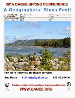
OAGEE Fall 2014 Conference Call for Presenters

Workshop and presentation proposals are now being accepted for the OAGEE Fall 2014. This Conference is to be held at Ryerson University, ON, October 17 & 18, 2014.  The deadline for submissions is June 1, 2014.

Sessions will run Friday morning, Friday afternoon and Saturday morning. Each session will be 50 minutes in length, with the option for a double session if additional time is required. Field trip requests of 2-3 hours are preferred.

Each classroom will hold approximately 25-30 participants with chairs and tables. Hard wire and/or Wireless Internet access, a projector, speakers, connecting PC cables are available in most rooms; Mac users must bring their own connectors. Smart Boards are NOT available at Ryerson. We do have access to a computer lab with 42 workstations.

All applicable workshop and presentation proposals will be considered for the conference. However, we are encouraging potential presenters to consider providing sessions that focus on the following highlighted session themes:

Conference Main Theme is: Sustainability

         Inquiry based learning

         Revised curriculum for Geography in Ontario

         Evidence Based Learning

         Gr. 7 & 8 Program

         Physical geography

         Urban Studies

         Geo-technology

         Blended Learning

         Eco-Schools

         Geo-Literacy

         Geo-Numeracy

         Skills for Post-secondary

         Differentiated Instructions in the Geography Classroom

         Essentials of Geography (reaching out to ALL levels of students)

         Field studies

         First Nations studies


One presenter from each accepted workshop will receive one, $100 discount towards their registration fee for the conference.  Additional presenters who wish to participate in OAGEE Fall 2014 Conference activities beyond their session are asked to register separately for the conference.  Notifications regarding successful submissions will be provided by the end of June 2014.

Educational Alliance for a Sustainable Ontario

Monday May 5, 2014"FNMI Perspectives and ESD"  9:30 am - 12:00 pm   OISE

I hope you are all enjoying this (finally!) warmer weather! Our next EASO meeting will be held on Monday May 5, 2014, at OISE. This meeting will explore "First Nations, Metis and Inuit Perspectives and ESD" .  

Please note: this is a shorter meeting than we typically have and it will begin at 9:30 am (9:00 am arrival) until 12 noon.   

 Please RSVP by April 24, 2014.    

Below you will find a list of updates from the EASO network. Please send any updates from your networks that you would like shared in this newsletter to esd_Ontario@lsf-lst.ca 

 If you have any questions, comments, or concerns, please do not hesitate to contact me at esd_ontario@lsf-lst.ca. Thank you all for your support and participation in EASO.

 All the best, Angela Heagle Kielbowski

NAAEE/EECOM Conference

October 8-11 2014 in Ottawa, ON

This conference is usually kicked off by a one-day research symposium.  

 Joint EECOM (Canadian Network for Environmental Education and Communication/Reseau canadien d'education et  de communication relatives à l'environnement) and NAAEE (North American Association for Environmental Education) Conference (43rd Annual NAAEE Conference).

This year's conference theme is "Building Momentum for the Next Chapter," and the call for presentations is available here. Be sure to follow us on Facebook and Twitter to stay connected! http://www.naaee.net/conference

OAGEE Fall Conference: October 17 - 18 @ Ryerson  in Toronto

Detailed itinerary & prices will be available soon.

www.Oagee.org

Maximum City offers award-winning summer programs and in-school curriculum in sustainable urbanism and civic literacy for students aged 13-18.

http://maximumcity.ca/

Student Mapping Competition

Canadian Cartographic Association (CCA)

http://cca-acc.org/wp-content/uploads/documents/CCA_Mapping_Annoucement.pdf


Issues

Climate Change

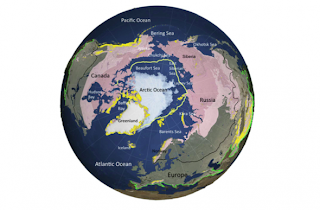
Climate Trends in the Arctic as Observed from Space: It's melting. Fast.

The ice cap is heating up & melting down at an alarming, not previously predicted rate

http://tiny.tw/3iMV

'Like a giant elevator to the stratosphere:' Newly discovered atmospheric layer may impact Earth's climate

An international team of researchers has discovered a previously unknown atmospheric phenomenon over the tropical West Pacific. Like in a giant elevator to the stratosphere, many chemical compounds emitted at the ground pass unfiltered through the so-called 'detergent layer' of the atmosphere, known as the 'OH shield.' The newly discovered phenomenon over the South Seas boosts ozone depletion in the polar regions and could have a significant influence on the future climate of the Earth.

http://www.sciencedaily.com/releases/2014/04/140404092931.htm


UN climate warning goes unheeded

The news from the UN is bad: None of us, we're told, not a single solitary one of us, will escape the consequences of climate change. Every individual, let alone nation, will be affected by the environmental crisis now unfolding around the planet.

http://www.thestar.com/news/gta/2014/04/03/un_climate_warning_goes_unheeded_hume.html


Agriculture

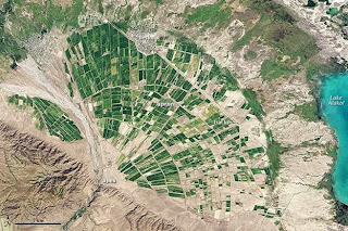
Alluvial Fan in Kazakhstan

http://tiny.tw/3iMW

Out of thin air: Using wind energy to make fertilizer

Did you know it's possible to use wind energy to make fertilizer? And did you know that it's being done right here in Minnesota, at the University of Minnesota's West Central Research & Outreach Center (WCROC) in Morris?

http://minnesotacornerstone.com/?p=1772


Population & Migration & Socio Economic Indicators

SOCIAL PROGRESS INDEX 2014

MEASURING NATIONAL PROGRESS – To truly advance social progress, we must learn to measure it, comprehensively and rigorously. The Social Progress Index offers a rich framework for measuring the multiple dimensions of social progress, benchmarking success, and catalyzing greater human wellbeing. The 2014 version of the Social Progress Index has improved upon the 2013 'beta' version through generous feedback from many observers. We continue to welcome your use and testing of our data, and feedback to help us continue to improve. Please watch our short video on the results of the Social Progress Index 2014._ fully interactive

http://www.socialprogressimperative.org/data/spi


Seven Billion – Typical Human – National Geographic Video

http://video.nationalgeographic.com/video/news/7-billion/ngm-7billion-typical?source=relatedvideo


India election: country awaits a demographic dividend or disaster

A generational shift is under way in India with half of the population under 24. How the 150m first-time voters cast their ballot will dictate the future

http://www.theguardian.com/world/2014/apr/07/india-election-demographic-dividend-disaster

Altar: The town where migrants shop for a perilous journey

In a Mexican border town, the shops are stocked for one thing - to equip migrants for the last leg of a long and sometimes fatal journey.

http://www.bbc.com/news/magazine-26870723


Sustainability

Is a Footprint the Right Metaphor for Ecological Impact?

http://blogs.scientificamerican.com/guest-blog/2014/04/02/is-a-footprint-the-right-metaphor-for-ecological-impact/


Urban

Visualizing 200 Years of Urban Sprawl in Paris, São Paulo, and L.A.

Two centuries ago, Paris, a city with a population of half a million, barely extended beyond its medieval footprint. São Paulo was still largely a small trading outpost for gold and exploration expeditions. And Los Angeles was just a pueblo of a few dozen buildings. By Richard Florida

Terrific Map animations ML

http://www.theatlanticcities.com/neighborhoods/2014/04/visualizing-200-years-urban-expansion-paris-sao-paulo-la/8794/

Urban story Maps of Cali Columbia

The World Urban Forum (WUF for their stands for World Urban Forum) is the Principal Cities World Conference, World's Premier Conference on Cities, organized every two years.

http://esri.co/geoapps/MapasTuristicos/

The Future of Transportation Atlantic Cities feature Report

http://www.theatlanticcities.com/special-report/future-of-transportation/


Resources & Energy

Global dip in renewable energy investment

Global investment in renewables fell by 14% during 2013, but the percentage of electricity generated by renewable sources still grew, a report shows.

http://www.bbc.com/news/science-environment-26923260

IPCC to debate future of fossil fuels at climate meeting
Read more: 
http://www.ctvnews.ca/sci-tech/ipcc-to-debate-future-of-fossil-fuels-at-climate-meeting-1.1762312#ixzz2yJGHBPJe

After concluding that global warming almost certainly is man-made and poses a grave threat to humanity, the UN-sponsored expert panel on climate change is moving on to the next phase: what to do about it.

The Intergovernmental Panel on Climate Change, or IPCC, will meet next week in Berlin to chart ways in which the world can curb the greenhouse gas emissions that scientists say are overheating the planet.

It is also trying to give estimates on what it would cost.

Read more: http://www.ctvnews.ca/sci-tech/ipcc-to-debate-future-of-fossil-fuels-at-climate-meeting-1.1762312#ixzz2yJGXx1AE

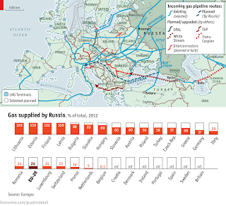
How American energy independence could change the world

The holy grail of American leaders over the past four decades, from Richard Nixon to Barack Obama, has been energy independence, and thanks to shale oil and gas, the dream could soon become reality.

http://www.bbc.com/news/business-23151813?ocid=socialflow_twitter


International Relations & Globalization

If not now, when?

This would be an especially good time for a change in America's relations with Cuba

The Economist http://tiny.tw/3iMU

Globalisation: good or bad?

Lewis Williamson outlines the main arguments for and against globalisation

http://www.bbc.com/news/science-environment-26923260

Disasters

It' s Officially Tornado Season: These Animations Show the Parts of the U.S. Most Likely to Get Hit

'North America has entered the beginning of peak tornado season, and the weather certainly reflects that. Today a major spring storm is barreling over the nation's center, and forecasters are warning to watch out for possible damaging winds, large hail, and tornadoes.

So perhaps now's the time to ask the age-old question: If you're terrified of twisters, where's the absolute worst place in the U.S. to live?

http://www.theatlanticcities.com/arts-and-lifestyle/2014/04/where-america-are-you-likely-see-tornadoes/8788/

Another Warning for the Northwest From Chile's Earthquake Hot Zone

As disaster agencies tally scattered deaths and damage from the 8.2-magnitude earthquake (and thankfullymodest tsunami) off the coast of northern Chile on Tuesday night, earthquake experts have been stressing two facts:

http://dotearth.blogs.nytimes.com/2014/04/02/another-warning-for-the-northwest-from-chiles-earthquake-hot-zone/

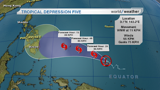
Tropical Depression Diagram

Topics & Teachables

Tools

7 Online Tools for Creating Charts & Diagrams

http://www.freetech4teachers.com/2014/04/7-online-tools-for-creating-charts.html#.U0QeYPldXTp

UrtheCast: a new tool for change

UrtheCast is committed to fostering global education and relief efforts worldwide, using advanced Earth Observation technology. From helping students detect geographical changes, to providing crucial footage for aid organizations responding to a crisis, UrtheCast will soon provide a powerful tool for change.

http://www.urthecast.com/community#mission

Topics

Tourism in Space –

A lesson that explores Space tourism. Pupils consider the demand, costs, impacts and work in groups. Could also be used for looking at different types of tourism

http://www.slideshare.net/JellyCarr/tourism-in-space-is-this-the-future

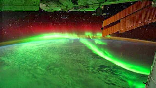
A stunning photograph of the Northern Lights seen from the International Space Station

NASA Wavelength 

is your pathway into a digital collection of Earth and space science resources for educators of all levels – from elementary to college, to out-of-school programs. These resources, developed through funding of the NASA Science Mission Directorate (SMD), have undergone a peer-review process through which educators and scientists ensure the content is accurate and useful in an educational setting. Use NASA Wavelength to quickly and easily locate resources, connect them to other websites using atom feeds, and even share the resources you discover with others through social media and email.

http://nasawavelength.org/

Coastal Decision-making Tools

Geographic information systems (GIS) are mapping tools used to integrate, store, edit, analyze, share, and display geographic information. NOS provides a variety of GIS data products to the coastal management community. Pictured above is the Sea Level Rise and Coastal Flooding Impacts Viewer that uses local elevation data and visualization software to allow users to see how one to six feet of sea level rise might affect their coastal communities.

http://oceanservice.noaa.gov/tools/dmtools/

Resource: Geoguessr – Where in the World?

Employing EdTech within different subjects can sometimes be a challenge for teachers, especially when exploring for activities that really add value to teaching and learning. A great website, with a couple of great uses is Geoguessr.com, which draws from the technology from Google Street view, but challenges the user to try and locate where the randomly generated image is taken from. Five locations are provided, and your score points based on your guess, compared to the actual location of the image. Indeed, you are able to click around the location, trying to pick up clues, which offers fantastic opportunities to talk about geographical, language, or environmental clues.

We've known about Geoguessr for a while, but in a bid o enhance the website further, the Swedish developers have now placed localised versions into BETA, allowing you to focus solely on the USAJapanSweden, or UK (<~ Click country to open), plus we have found that the site works well on most operating systems, including mobiles. On the original version of the game, you can share a link to play challenge others with the same game you played…now, there's a thought!

http://ukedchat.com/2014/02/25/resource-geoguessr-where-in-the-world/

Discover Geography

A brand new exciting resources website created for geography teachers by Discover the World Education and the Geographical Association to be launched by April 14th.

The site will be developed over the coming years. Initially, we will be offering you resources relating to Iceland. Later in 2014 you will find material on Norway, Azores and China. In early 2015 we plan to develop resources relating to Italy and beyond.

http://www.livingplanetblog.co.uk/2014/03/discover-geography-.html

European word translator

You have to try it - ML

http://ukdataexplorer.com/european-translator/


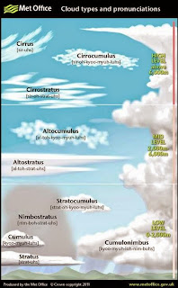
Want to learn the difference between a Cirrus and a Cumulus cloud? Our cloudspotting guide can help

25 Biggest, Tallest, Deepest, And Smallest Places In The World

From the dark depths of the ocean to some of the highest peaks on Earth these are the 25 biggest, tallest, deepest, and smallest places in the world! –Great Visuals ML

http://tiny.tw/3iN3

SPATIALWORLDS Literacy, Geo-literacy!

The Spatialworlds blog is a repository of teaching resources, images, commentary and website links for those interested in spatial education, spatial technology and geography in schools.

http://spatialworlds.blogspot.ca/2014/03/literacy-geo-literacy.html?spref=tw

A New Geo-Tagged Storytelling Site Might Be The Ultimate Travel Tool

How do we discover new cities to visit? How do we remember where we've been? With all the tools at our fingertips, I'd still argue it's actually not all that easy. Hi, which just opened to the public today, is a beautifully designed way to find, share, and tell stories about places.

What Hi is, exactly, is kind of hard to explain so I tried to come up with some shorthand ways to describe it: Literary Yelp, Instagram Longreads, Foursquare for Cities, a crowdsourced New York Times Travel section.

http://gizmodo.com/a-new-geo-tagged-storytelling-site-might-be-the-ultimat-1551278242


Mark Lowry

Geography and Spatial Technologies Instructional Leader

Social World Studies and Humanities

Toronto District School Board

1 Civic Center Court, Toronto , M9C 2B3

Tel (416) 394-7269   Cell (416) 576 -4515

http://tdsbweb/_site/ViewItem.asp?siteid=63&menuid=63&pageid=63

http://geographysites.blogspot.ca/

twitter @geogmark